 The Mason Dixon Line is probably best known as the boundary line between the North and South during the Civil War. It derived
its name from two surveyors from London, named Charles Mason and Jeremiah Dixon, who were employed to survey the long
contested boundary dispute between William Penn, for Pennsylvania and Lord Baltimore, for Maryland.
The western edge of Delaware is defined by the Mason-Dixon Line. The Delaware boundary lines began at a spot on the East Coast
between the 38th and the 39th parallels and continued west to the midpoint between the Atlantic and the Chesapeake Bay, about
thirty-five miles. That survey was done in 1751 and was accepted by Mason and Dixon. When Mason & Dixon were called in they
started at that 'Middle Point' and headed north 3' 36'6' west for 82 miles to a tangent point of the 12 mile circle. At the tangent point
the line bulges westward following the circle to a point 1.452 miles North, where it again lines up with the north heading for another
3.568 miles to the Pennsylvania line. The bulge is so slight that it is not even depicted on most maps. At the Pennsylvania line the
Mason Dixon line heads west along Latitude 39' 43'18' for 233 miles to the end of the Maryland Line. They had to stop at that point as a
result of uncooperative Indians. The line was agreed upon as being fifteen miles south of the southernmost latitude of the city of
Philadelphia.
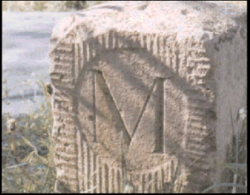
In order to mark the boundary, stones were brought from England and set every mile. Each milestone had a 'P' carved on one side and
an 'M' on the other. (Delaware was part of Pennsylvania at the time) Every fifth milestone had the coat of arms of Lord Baltimore
on the Maryland side and the coat of arms of the Penn family on the Pennsylvania side.
When Mason and Dixon were surveying the northern part of Delaware they stayed for a long time along with their large group of
assistant surveyors, chain-carriers, and a legendary tame bear, at St. Patrick's Inn, now known as the Deer Park, in Newark.
Over the years many of the marker stones were lost and in 1849 a commission from the three states, Maryland, Pennsylvania and
Delaware, was appointed to determine the place of a missing stone which marked where the three states came together. Even after
eighty years of technical advances in surveying it was discovered that Mason and Dixon were extremely accurate, and when a hole
was dug to set the new stone in the proper place, they found the lower portion of the old stone placed there by Mason and Dixon.
Since the twelve mile radius did not connect with the North-South line until five miles below the East-West line, a wedge of
approximately 800 acres was developed. Which state owned the wedge remained in dispute until 1893, when it was awarded to
Delaware.
|
