A historic marker placed by the State of Delaware in 1932 along old Rt. 896 in Glasgow reads:
	AIKEN'S TAVERN
	Site of old Aiken's Tavern. Quarters of General
	William Howe, September 3 to 8, 1777.
	Tavern then owned by Mathew Aiken, who
	laid out this village, naming it Aikentown.
Renamed for Glasgow in Scotland. |
|
Actually, Matthew Aiken did not purchase the tavern and land until 1791, from James Stewart, Philadelphia merchant. Mathew's brother
John Aiken was operating the tavern in 1777 when the British troops quartered there, just before the battle of Cooch's Bridge. When
Matthew purchased the tavern and about nine acres of land, only a few buildings existed in the village.
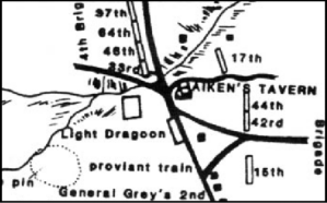
It was Aiken's intention to lay out a planned single street village with the tavern as the crossroads. The road went north to Cooch's Bridge, south to Middletown and west to Elkton. The road heading east to New Castle started just south of the Tavern and passed behind the Pencader Church. The remains of this road can still be seen on the church property. Aiken's Tavern was about 1200 feet north of the present intersection of Route 896 and Route 40; prior to 1800 the intersection was at the tavern. The present day intersection was laid out as a result of a petition in 1799, making the new crossroad approximately that of the current westbound lane of Route 40.
William Nielson, tavern keeper, advertised the tavern and adjacent store for sale, in August of 1796. It was described as a two-story, brick
dwelling house, 'neatly finished', 48 feet in length and 32 in breadth, each story ten feet high. There was a cellar under the entire building, which was divided into five apartments. The first story contained four rooms and a large passage, with a fireplace in each; the second story had five rooms, with four fireplaces. The garret was divided into three rooms.
The complex around the tavern boasted a brick storehouse, a two-story granary capable of holding 10,000 bushels of grain, brick
smokehouse, and kitchen, frame wash house, hen house, log house and a stable 45 feet in length that could shelter 20 horses.
In 1832 the hotel was torn down, and a new one erected on the opposite side of the road, nearly opposite the former site. Materials
from the old tavern were used by the Cann family to build a house just south of Glasgow, but that house no longer stands.
The state historic marker, placed in 1933, marks the spot where the historic inn stood. A map know as "Major Andre's Map", drawn at the time of the battle at Cooch's Bridge, shows the former location of one of Pencaders most historic landmarks.
|
